Geocoding accuracy has two parts: how many addresses match at all, and how far each matched point lands from the real building. Published studies give a sobering answer for the common method, interpolating along street centrelines: in a peer-reviewed test of 3,000 homes in upstate New York, 95% of street-geocoded points fell within 152 metres of the house in cities, 421 metres in suburbs and 2,872 metres in the country, while points taken from property parcels fell within 21, 39 and 195 metres. For a commercial property schedule, where a pin decides the flood zone, the distance to the coast and the fire protection class, "geocoded" is therefore not a quality measure. Botminds' Schedule of Values Validation reports five measures instead, for every schedule, before the account is priced: match rate, precision mix, value left on a postal-code centre, correction distance and zone changes.
The studies below measured homes, mostly in the 2000s, with the geocoders of the day; the numbers date, the mechanisms do not. The worked example uses the solution's sample data, a fictional 42-location Gulf Coast logistics renewal.
Ninety-five per cent of street-geocoded homes landed within these distances; parcel points far closer
How accurate is geocoding? What the error studies measured
Street geocoding is accurate to tens of metres in dense cities and can be kilometres off in the country; parcel-based points are roughly ten times closer. The New York study behind the chart above is the clearest single measurement, because its authors established the true location of each home from aerial imagery and sent staff with GPS units to the 326 they could not confirm from the office. Mean street-geocoding error was 58 metres urban, 143 suburban and 614 rural; the worst rural point was 18,742 metres from its house (Cayo and Talbot, 2003).
The authors also tried tuning the software, adjusting how far a point is set back from the street centreline and how far from a corner. The best combination reduced the overall mean error from 272 to 265 metres. The lesson for a property desk: the method, not the settings, sets the accuracy. If parcel or building points are available, the gain from using them dwarfs anything a setting can buy.
A larger, more recent comparison points the same way in a dense city. Geocoding 21,183 New York City addresses three ways, researchers measured the distance from each street-segment and parcel-centroid point to the address point, taken as the reference: a mean of 29.2 metres for street segments and 15.9 for parcel centroids. They added a detail worth remembering: "there were no distance errors of zero; each of the three methods generated a different point location for all 21,183 addresses" (Kinnee and others, International Journal of Environmental Research and Public Health, 2020).
Match rate is not accuracy
A geocoder that matches every address can still place many of them badly, and the most precise methods match the fewest. In the New York State study, exact matches on house number, street name and ZIP code reached 93.8% of urban addresses, 86.7% suburban and 61.9% rural. The authors were explicit: "Match rates alone are not sufficient to evaluate a geocoding result."
The more precise the reference data, the more addresses it fails to find
That trade-off is why a property schedule needs a cascade rather than a single method: try the building, then the parcel, then the street, and record which one succeeded for each location. A schedule geocoded entirely at street level will report a near-perfect match rate and hide every rural location's real error. A schedule geocoded only to parcels will look less complete and be far more accurate where it matched. Neither number alone tells an underwriter whether to trust the pins.
What is the difference between rooftop, parcel and street geocoding?
They differ in what the reference data knows about the place. A rooftop or building point comes from a dataset of structures, so the pin lands on a building. A parcel point is the centre of the tax parcel, which on a small lot is the building and on a 40-acre distribution yard may be a car park. A street point is interpolated along a street segment from the house-number range, set back from the centreline by a default offset. Below those sit intersections, postal-code centres and city centres, which say only roughly where the location is.
The placement ladder: what each level knows, and what to do with it on a schedule
| Placement | What the point represents | Error measured in published studies | What to do before pricing |
|---|---|---|---|
| Roof or building | A mapped structure at the address | Used as the reference in the studies above | Accept; record the source |
| Parcel | Centre of the tax parcel | Median 8–15 m, 95th percentile 21–195 m (homes, New York State) | Accept on small lots; check large sites, where the centre may miss the building |
| Street segment | Point interpolated along the street’s number range | Median 38–201 m, 95th percentile 152–2,872 m (homes, New York State) | Review near flood-zone lines, the coast and in rural areas |
| Intersection | Where two named roads meet | Not measured; depends on the road | Send to a person: find the building |
| Postal-code centre | A centre of the ZIP code area | Not a location; can be kilometres from the building | Never price on it; send to a person |
Why geocoding errors are not random
Geocoding error is biased, not noise that averages out, and the bias runs toward the street. Writing in Environmental Health Perspectives, the geographer Paul Zandbergen put it plainly: "the positional errors in street geocoding are not random in nature. Typical street geocoding employs a standard offset from the roads in the placement of the geocoded locations. In many areas, however, the actual residence is located at much greater distances, especially in rural areas" (Zandbergen, 2010).
For commercial property the same bias has a direction that matters. Port warehouses, cold stores and truck terminals sit back from public roads behind yards and docks, often toward the water. A point dropped on the access road lands on the landward side of the building, sometimes on the other side of a flood-zone boundary or a coastal band. The NAIC's catastrophe modeling primer names the perils where this bites hardest: "The uncertainty in the model's loss estimates increases as the geocoding resolution decreases from high to low," which "is particularly true for high gradient perils like wildfires and floods, as the hazard varies greatly over short distances" (NAIC Catastrophe Modeling Primer, exposure draft, December 2024).
Fire protection has its own line. In Texas, the state fire marshal's office explains that a split classification applies one class to properties within five road miles of a fire station and within 1,000 feet of a creditable water supply, and a worse one to properties within five road miles but more than 1,000 feet from water (Texas Department of Insurance, FAQ: Public Protection Classification). A pin a few hundred feet off can change which side of that line a building is on.
How far off can a geocode be in rural areas?
Kilometres. In the New York study, one rural home in twenty was geocoded more than 2,872 metres from where it stood, and the authors traced many errors over 5 km to wrong postal-code boundaries in the software's reference files. A study of 135 rural addresses in West Virginia found a second cause, old rural-route addresses: "Without E911 address conversion, 25% of the geocodes would have been more than 1000 meters from the true location" (Vieira and others, Environmental Health, 2010).
The same West Virginia study is a warning about trusting a single service. Two geocoding services, run on the same addresses, placed them with median errors of 39 and 188 metres, and the less accurate one misclassified seven addresses relative to the public water lines the study cared about. A property schedule's equivalent of a water line is a flood-zone boundary. What FEMA's Zone X means, and why a pin in the wrong place can change it, follows one location across that boundary.
Five measures of geocoding accuracy for a property schedule
A schedule needs five numbers, each answering a different question an underwriter or a reinsurer will ask. The first three describe the placement before anyone touches it; the last two describe what correcting it changed.
Five geocoding accuracy measures for a schedule of values
- 1
Match rate
Locations matched to any point ÷ locations on the schedule
A location that does not match is not modeled where it is; it is modeled wherever the fallback puts it, or not at all.
- 2
Precision mix
Share of total insured value placed on a roof or parcel, on a street segment, and on an intersection, postal code or city
Count by value as well as by location: one unplaced port warehouse outweighs ten placed shops.
- 3
Value on a postal-code centre
Total insured value whose best placement is a ZIP centroid or coarser
The single number to print at the top of an exposure file. It should be zero, or named location by location.
- 4
Correction distance
Distance each pin moved when a person corrected it: median and largest
Shows how wrong the first placement was, and whether the geocoder errs on particular kinds of address.
- 5
Zone changes
Locations and value whose flood zone, coast band or protection class changed after correction
The measure that connects accuracy to price. A few metres matter only when they cross a line.
Two choices make the measures honest. Weight by value, because the schedule's risk is in its value, not its row count; a missed postal-code match on the largest building matters more than five on the smallest. And keep the correction log, because a measure of how far pins moved is the only evidence of how wrong the first placement was. A geocoder that is never corrected looks perfect.
The five measures on one sample schedule
Take the sample renewal as it runs through the solution: 42 locations from Victoria, Texas to Pensacola, Florida, total insured value $989.49M as submitted. After the first pass the geocoder had 39 locations on a roof and three to fix, among them one on a postal-code centre and one on an intersection.
A location on a postal-code centre, with the agents' best match drawn to the building
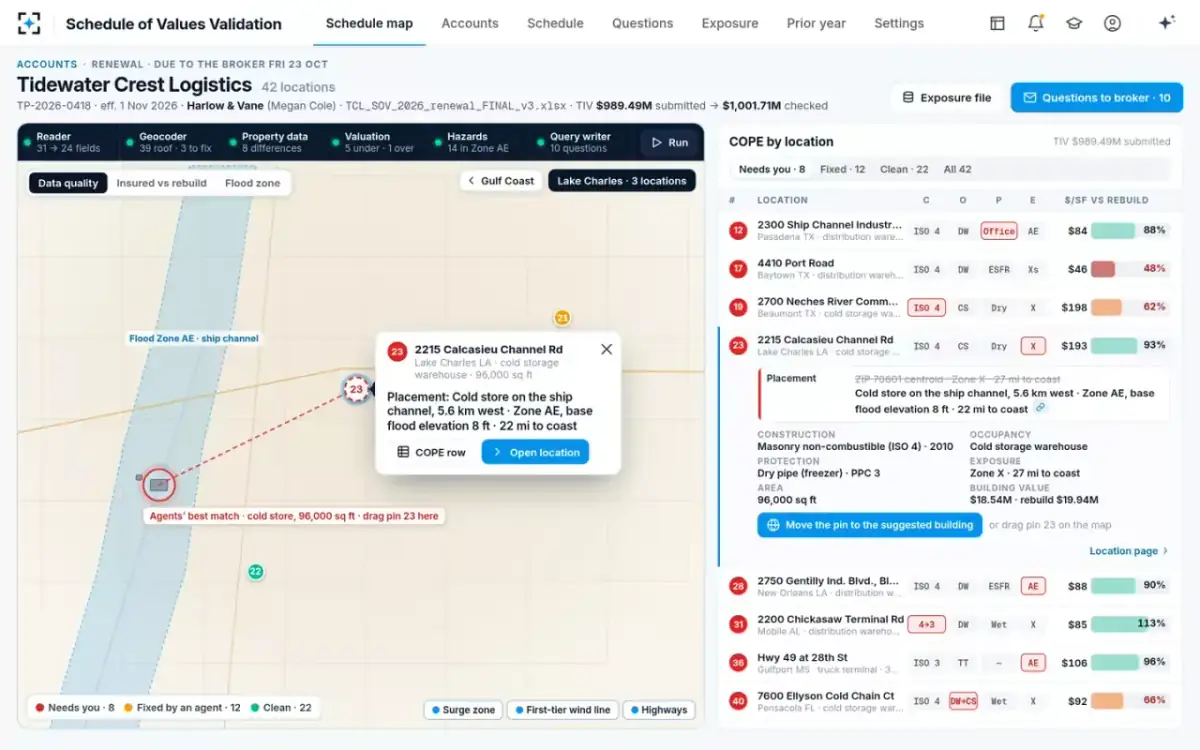
Measured, the schedule reads like this. Match rate: 42 of 42 matched to some point, which on its own says nothing. Precision mix before correction: 39 on a roof, one intersection, one postal-code centre. Value on a postal-code centre: one location, the cold store at 2215 Calcasieu Channel Road in Lake Charles. Correction distance: 5.6 km, when the underwriter dragged it onto the building the agents had found. Zone changes: one location from flood Zone X to Zone AE, base flood elevation 8 feet, taking $34.71M of value into the high-risk zone and moving its distance to the coast from 27 to 22 miles.
One drag: the pin moves to the roof, and the flood zone and exposure file follow
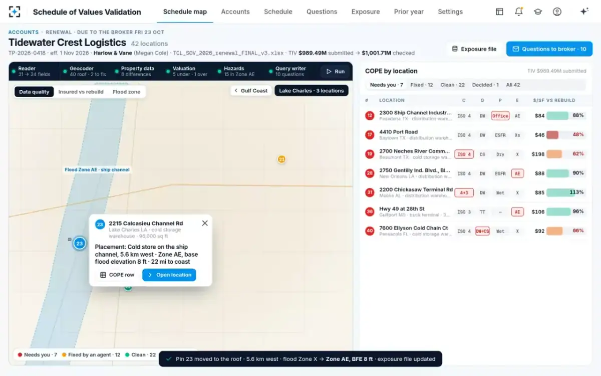
After correction, the exposure file shows 40 locations on a roof, none on a postal-code centre, one still on an intersection (a truck terminal described as "Hwy 49 at 28th St" in Gulfport, Mississippi, named at the top of the file), and the duplicate removed. Total value in Zone AE rose by $16.94M net: $34.71M in from the cold store, $17.77M out with the duplicate row. None of that was visible in a match rate of 100%. What the cat modeling analyst does with the file picks up from here.
What regulators ask about geocoding in a rate filing
They ask how precisely the book is placed, in so many words. The NAIC primer's list of questions a department may put to an insurer that uses catastrophe models includes: "Explain in detail how the company geocodes property locations," "How complete is the information (exact vs. zip code vs. street level)" and "What percentage of the insured properties was coded to street address, zip code, city or county?" Measures 2 and 3 above answer those questions directly, for an account or a book.
The questions do not set a standard; they ask the insurer to show its own. When a department, a reinsurer or a rating agency asks, the answer is either a table or an afternoon of reconstruction.
Setting a placement standard before pricing
Decide, before the season, what placement an account must reach before it is priced, and who may override it. The default in the solution is roof or parcel, with postal-code and intersection matches routed to the underwriter; the options are roof only, roof or parcel, or street or better. A team that writes inland retail may choose street or better; a team that writes Gulf Coast warehouses should not.
A placement standard a property desk can enforce
- Name the precision required before pricing
Roof or parcel is a defensible default for coastal and flood-exposed property.
- Route every postal-code and intersection match to a person
With the agents’ best guess at the building drawn on the map, never applied silently.
- Check large parcels even when they matched
A parcel centre on a big industrial site can be hundreds of metres from the building that matters.
- Re-run hazard lookups whenever a pin moves
Flood zone, base flood elevation, coast distance and protection class follow the pin, not the address.
- Report value on low-precision placements at the top of the exposure file
So the modeler and the reinsurer see it without searching.
- Keep every correction with its distance
It is the evidence for measure 4, and the trail an examiner or a claims adjuster will ask for later.
To see the five measures on the sample renewal, start from Schedule of Values Validation.
Questions people ask
What is geocoding precision level?
Precision level, sometimes called match level, records what a geocoded point was matched to: a building, a parcel, a street segment, an intersection, a postal code or a city. It is a label, not a distance. A schedule should carry it for every location, because two points with the same coordinates format can be metres or kilometres from the building depending on their level.
What is a ZIP centroid geocode?
It is a point at a centre of the ZIP code area, used when an address cannot be matched more precisely. Florida's hurricane model standards require that ZIP centroids used in a model be based on population data, which places them where people live rather than where a port warehouse stands. On a commercial schedule a ZIP centroid should be treated as unplaced.
What is rooftop geocoding?
Rooftop geocoding places the point on the building itself, using a dataset of mapped structures or address points rather than interpolating along a street. It is the most precise level for a single-building location, though a large site with several buildings still needs the right building chosen.
Can a geocoding error change a building's fire protection class?
It can. Protection classes are often split by distance: in Texas, one class applies within five road miles of a fire station and 1,000 feet of a creditable water supply, another beyond 1,000 feet. A pin placed on the street rather than the building can land on the wrong side of either line.
Why does geocoding accuracy matter for insurance pricing?
Because the hazard is read at the pin. Flood depth, distance to the coast, wind band, wildfire exposure and protection class all come from the location, and for flood and wildfire the hazard changes over short distances. A misplaced point prices the wrong building's hazard, and the error usually leans one way.