FEMA flood zone X marks land outside the special flood hazard area, the area FEMA expects to flood in the 1%-annual-chance or "100-year" flood. Shaded Zone X is a moderate flood hazard area, between the limits of the 1% flood and the 0.2%-annual-chance or "500-year" flood; unshaded Zone X is a minimal flood hazard area, higher than the 0.2% flood. Zone X is not a statement that a building will not flood: FEMA's own flood insurance site says that one in three flood insurance claims comes from low- and moderate-risk zones. On a commercial property schedule there is a second problem. The zone is read at a point, and if the point is a postal-code centre or the wrong building, "Zone X" describes somewhere else. Botminds' Schedule of Values Validation reads flood zone, base flood elevation and distance to the coast at each building's own pin, re-reads them whenever a pin moves, and shows the underwriter total insured value by zone, as submitted and as checked.
The zone definitions on this page are FEMA's. The examples come from the solution's sample data, a fictional 42-location Gulf Coast logistics renewal.
Zone X unshaded, Zone X shaded and Zone AE: what each means for a commercial building
| Zone X, unshaded | Zone X, shaded | Zone AE | |
|---|---|---|---|
| FEMA hazard label | Minimal flood hazard | Moderate flood hazard | Special flood hazard area (high risk) |
| Where it sits | Above the 0.2%-annual-chance flood elevation | Between the 1% and 0.2%-annual-chance flood limits | Inundated by the 1%-annual-chance flood; base flood elevation determined |
| Older map label | Zone C | Zone B | Zones A1–A30 |
| Federal mandatory purchase for federally backed loans | No | No | Yes, in participating communities |
| Base flood elevation on the map | No | No | Yes |
| What a schedule should carry | Zone, and floor elevation if known | Zone, distance to the AE line, floor elevation if known | Zone, base flood elevation, floor elevation, foundation |
What does flood zone X mean on a FEMA map?
Zone X is FEMA's label for land outside the special flood hazard area, split into a moderate and a minimal band. FEMA's glossary defines the special flood hazard area as "the area that will be inundated by the flood event having a 1-percent chance of being equaled or exceeded in any given year," labelled with the A and V zones. Outside it, "Moderate flood hazard areas, labeled Zone B or Zone X (shaded)" lie "between the limits of the base flood and the 0.2-percent-annual-chance (or 500-year) flood." And "The areas of minimal flood hazard, which are the areas outside the SFHA and higher than the elevation of the 0.2-percent-annual-chance flood, are labeled Zone C or Zone X (unshaded)" (FEMA, Flood Zones).
The B and C labels survive on older maps. A schedule built from old flood determinations can carry B, C and X side by side for buildings in the same kind of place, which is one reason to re-read every zone from the current map rather than copy last year's column.
Shaded vs unshaded Zone X: the 0.2-percent line
The shading separates land that would flood in a 0.2%-annual-chance event from land that would not. Shaded X is inside the 500-year floodplain but outside the 100-year one; unshaded X is above both. FloodSmart adds a detail that matters for commercial sites: shaded areas "may have reduced their risk with mitigation efforts such as levees, or experience shallow flooding, with water usually less than 1 foot deep or covering less than 1 square mile" (FloodSmart, What is my flood zone?).
Two consequences follow for an underwriter. A shaded-X location behind a levee is protected against the 1% flood only as long as the levee holds, so its moderate label depends on a structure, not on height. And a shaded-X location close to the AE line is a short distance from a different answer: on a large industrial site, the building may be in one zone and the yard or the parcel centre in another. A note of caution about summaries: FloodSmart's own FAQ on the same page lists "Low Risk: B & X" and "Moderate Risk: C & X," the reverse of its zone descriptions above it. Read the map's legend and FEMA's definitions, not a summary table.
Three numbers to keep beside a Zone X location
1 in 3
flood insurance claims come from low- and moderate-risk zones, per FEMA’s FloodSmart
0.2%
annual chance: the flood whose limit separates shaded from unshaded Zone X
$500K
NFIP maximum building cover for a non-residential building, plus $500K for contents
Is flood zone X a high-risk area? One claim in three says do not assume it is safe
Zone X is not a high-risk area in FEMA's terms, but it is not a no-risk area either. FloodSmart puts it directly: "Zones C & X are at a lower risk of flooding, though not entirely without risk," and "1 in 3 flood insurance claims come from low- and moderate-risk zones." For a building that changed zone after a map update, the same page says: "Your risk is reduced, but not removed."
For commercial property the point is sharper than for homes, because the values are larger and the federal flood program covers little of them. The NFIP's maximum for a non-residential building is $500,000 of building cover and $500,000 of contents (FEMA NFIP, simple guide for non-residential buildings). A distribution warehouse worth $20 million in shaded Zone X is insured for flood, if at all, almost entirely in the commercial market, which prices on the location's own flood hazard, not on the federal label.
Zone X vs AE for a commercial building
The difference is the 1%-annual-chance flood and what follows from it: a base flood elevation, the federal purchase requirement and floodplain building rules. Zone AE is inside the special flood hazard area, and the map shows its base flood elevation, the height the 1% flood is expected to reach. In communities in the National Flood Insurance Program, FloodSmart notes, flood insurance in the A zones "is mandatory if mortgages are government-backed." In Zone X it is recommended, not required.
For underwriting, the base flood elevation is the more useful number than the letter. A building in AE whose floor sits several feet above the base flood elevation may face less flood damage than a building in shaded X with a basement. That is why the schedule should carry floor elevation where it is known, and leave it as unknown where it is not, rather than inferring it from the zone.
Since Risk Rating 2.0, the zone no longer sets the NFIP premium
Under the NFIP's Risk Rating 2.0, the federal premium is set from the building, not the zone. The Congressional Research Service summarised FEMA's change: "flood zones will no longer be used in calculating a property’s flood insurance premium following the introduction of Risk Rating 2.0," and the premium is instead based on features such as "the foundation type of the structure, the height of the lowest floor of the structure relative to base flood elevation, and the replacement cost value of the structure" (Congressional Research Service, R45999, updated 2 November 2021).
The zone did not disappear. The same report notes that zones "will still be used for floodplain management purposes, and the boundary of the Special Flood Hazard Area will still be required for the mandatory purchase requirement." For a property underwriter the lesson runs the same way as the federal program's: the zone is a screening label and a legal boundary; the flood loss depends on the building's own elevation, foundation and value at its own location.
Why a schedule needs the flood zone for every location
Because flood hazard changes over short distances, an account-level answer is wrong for most of the account. A 42-location logistics schedule along the Gulf Coast can have buildings in AE on a ship channel, in shaded X a mile inland and in unshaded X on higher ground in the same county. Florida's flood model standards, written for the models that price residential flood in that state, say why it matters: "Flood model outputs, including flood loss costs and flood probable maximum loss levels, are sensitive to insured exposure locations and topography" (Florida Commission on Hurricane Loss Projection Methodology, Flood Standards Report of Activities, as of 1 November 2025, standard AF-3).
One sample schedule's value by flood zone, as submitted and as checked
The totals move in both directions, which is the point. One location moved into AE when its pin moved onto the building; one AE row came out because it was the same building listed twice. A cat modeling analyst who received the submitted file would have modeled $17.77M of flood value twice and missed $34.71M where the water would be. What the cat modeling analyst does with the checked file follows it into the model.
Can a pin in the wrong place change the flood zone?
Yes, and it is the most common way a schedule's flood answer goes wrong. In the sample renewal, location 23, a cold store at 2215 Calcasieu Channel Road in Lake Charles, Louisiana, was not in the address file, so it matched only the 70601 postal-code centre, in Zone X, 27 miles from the coast. The agents searched the parcels along the channel road and found a 96,000 square foot cold store 5.6 km west, on the ship channel, in Zone AE with a base flood elevation of 8 feet, 22 miles from the coast. They drew a dotted line to it and left the pin where it was.
Pin 23 moved to the roof: Zone X becomes Zone AE, base flood elevation 8 feet
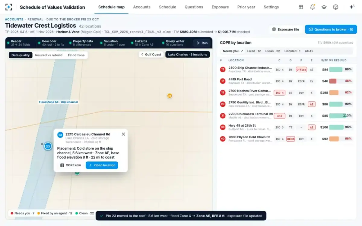
The underwriter moved the pin. The hazard mapper re-ran, and $34.71M of value went into Zone AE. Nothing on the broker's spreadsheet suggested a problem: the address looked complete and the zone looked reassuring. How to measure geocoding accuracy on a schedule sets out how often, and how far, points like this one miss.
How do you find the flood zone for a building?
From FEMA's flood maps, at the building's location. FloodSmart points property owners to the FEMA Flood Map Service Center or the community's floodplain administrator, and notes that maps change: an owner may ask FEMA to amend or revise a zone through a Letter of Map Amendment or a Letter of Map Revision, and communities' maps are updated over time. For a schedule of many locations, the practical route is a published flood-zone layer read at each building's coordinates, with the map date recorded.
Two habits keep the answer honest. Read the zone at the building, not the parcel centre or the postal code, and record how precisely the building was placed. And re-read it at every renewal and whenever a pin moves, because both the map and the pin can change. In Schedule of Values Validation the hazard mapper reads published hazard layers only, and re-runs on every location whose pin a person moves.
Reading Zone X on a schedule: what a property underwriter checks
Treat Zone X as the start of a flood question, not its answer. The checks below take minutes per location once the pin is right, and they catch the cases where the label hides the hazard.
Six checks for a Zone X location on a commercial schedule
- Confirm the pin is on the building
A zone read from a postal-code centre, an intersection or a large parcel’s centre may belong to somewhere else.
- Note shaded or unshaded
Shaded X is inside the 0.2%-annual-chance floodplain; unshaded is above it.
- Measure the distance to the nearest AE or VE boundary
A building a few metres from the line is a different risk from one a mile away.
- Ask whether a levee is doing the work
Shaded X can mean protected by a levee; the protection is only as good as the structure.
- Record floor elevation and foundation if known, and unknown if not
Never infer a favourable elevation from the zone; send unknown to the model.
- Re-read the zone at every renewal
Maps are revised and amended; last year’s column may be last decade’s map.
To see each location's flood zone read at its own pin in the sample renewal, start from Schedule of Values Validation.
Questions people ask
Do you need flood insurance in zone X?
The federal mandatory purchase requirement does not apply in Zone X; it applies to buildings in the special flood hazard area with federally backed loans in participating communities. FloodSmart strongly recommends cover anyway, since one in three flood insurance claims comes from low- and moderate-risk zones. A lender or a landlord can still require it by contract.
What is a special flood hazard area?
It is the area FEMA expects to be flooded by the 1%-annual-chance flood, the base or 100-year flood. On flood maps it carries the A and V zone labels, such as A, AE, AH, AO, VE and others. Its boundary is what triggers the federal mandatory purchase requirement for federally backed loans.
What is the NFIP flood insurance limit for a commercial building?
For a non-residential building in the NFIP's regular program, the maximum is $500,000 of building cover and $500,000 of contents cover, per FEMA's guide for non-residential buildings. Larger commercial buildings need excess or private flood cover above that.
What does flood zone D mean?
Zone D marks areas with possible flood hazards where no flood hazard analysis has been done, so the risk is undetermined. FloodSmart notes that undetermined does not mean no risk and that NFIP rates there reflect the uncertainty. On a schedule, a D location deserves the same scrutiny as an unknown.
Can a building's flood zone change?
Yes. Flood maps are revised as communities are restudied, and owners can request a Letter of Map Amendment or Revision through FEMA. A zone on last year's schedule may come from an older map, which is why the zone should be re-read from the current layer at each renewal.