Drone roof inspection software is the software that plans a drone's flight over a roof, captures the images, stitches them together and turns them into something usable: a roof measurement report for an estimate, or a damage reading that says what share of the roof surface is missing. Roofers, inspectors and insurers all buy it. For an insurer handling a hurricane or hail storm, the flight is the easy part. The hard part is getting thousands of readings onto the right claims, with the capture date and resolution a reviewer needs, in time to decide which homes get an adjuster first. Botminds' Catastrophe Claims Management is not drone software and does not fly anything. It reads the post-event aerial and drone imagery a carrier already buys, compares it with the pre-event capture, puts the reading on each claim and uses it to route the claim, leaving every decision about payment to an adjuster.
Examples come from a fictional event, Hurricane Delphine, run by a fictional carrier, Corvane Mutual, through the solution; the figures are sample data, not a customer result. The rules come from federal aviation regulations, Florida and Washington law and the NAIC's model regulation, linked where they appear.
Six systems a catastrophe claims team already runs, as Catastrophe Claims Management connects them
Claim system
Read from itFirst notices from phone, web, app and agents
ProducedThe event tag, a route and its reason on each claim
Before it countsAdjusters can re-route any claim
Advisories and perimeters
Read from itStorm track, wind field, surge, hail swath or fire perimeter
ProducedA dated footprint, one per advisory
Before it countsKept, never edited
Policies in force
Read from itLocations and coverages inside the footprint
ProducedThe list of exposed policies and those not yet reported
Before it countsNo outreach without the director
Aerial and drone imagery
Read from itPost-event captures against pre-event ones
ProducedA reading per address, with capture date and resolution
Before it countsRoutes only; an adjuster confirms on site
Adjuster rosters
Read from itStaff and outside firms, staging and daily capacity
ProducedZones by drive time, routes, the outside request
Before it countsManager assigns and signs; director approves large spend
Power outage reports
Read from itOutages by ZIP code
ProducedAn input to the forecast of who has not reported
Before it countsShown with the forecast, never acted on alone
What drone roof inspection software does, and what an insurer needs from it
It does four jobs: flight planning, capture, processing, and output. The flight plan sets the drone's path and height over the roof; the capture takes overlapping photos or video; the processing assembles them into a single image or model; and the output is a report. For a roofing contractor, the report is a measurement: pitches, areas and lengths for an estimate. For an insurer after a storm, the output that matters is a reading of damage, and it matters only if it reaches the claim.
An insurer buying drone roof inspection software should therefore judge it by its output as much as by its flight. Can each reading carry the address, capture date, resolution and the pre-event comparison? Can it be delivered in bulk, thousands of addresses a day, in a form another system can read? Does it separate what it measured from what it inferred? A tool that produces a beautiful report one roof at a time solves a contractor's problem, not a catastrophe team's.
Drone roof inspection certification: what the pilot needs
In the United States a commercial drone pilot needs a remote pilot certificate with a small UAS rating. The federal rule is direct: "no person may manipulate the flight controls of a small unmanned aircraft system unless" that person holds the certificate or is under the direct supervision of a remote pilot in command who can take control at once. The certificate belongs to the pilot, so a carrier buying captures from a vendor is relying on the vendor's pilots holding one.
The flight rules that shape a drone roof inspection after a storm
| Rule | What it requires | Why it matters after a catastrophe |
|---|---|---|
| 14 CFR §107.12 | A remote pilot certificate with a small UAS rating, or direct supervision by someone who has one | Every drone capture on a claim needs a certificated pilot, whether staff, contractor or vendor. |
| §107.31 | The pilot or a visual observer must see the drone throughout the flight | One crew, one roof at a time; drones do not scale to a whole county the way aircraft captures do. |
| §107.51 | No higher than 400 feet above ground, unless within 400 feet of a structure | Low enough for roof detail; too low to cover a footprint quickly. |
| §107.47 with §91.137 | Comply with temporary flight restrictions, including those over disaster areas | The airspace over the worst damage can be closed to all but relief flights in the first days. |
The last row is the one catastrophe teams forget. The FAA can issue a temporary flight restriction over a disaster area, among other reasons to "Provide a safe environment for the operation of disaster relief aircraft", and drone pilots must comply with it. The first days after landfall, when a carrier most wants imagery, are when the airspace is most likely to be restricted. It is one reason to plan aircraft or satellite captures for the first days, with drones following for single properties once the airspace allows.
Aerial roof measurement report vs a damage reading
A measurement report says how big the roof is; a damage reading says how much of it is gone. They answer different questions and belong at different moments. The measurement report feeds the estimate, after the adjuster has decided the roof is covered and needs repair or replacement. The damage reading feeds the routing, before anyone has visited: it decides whether a claim needs a field adjuster at all, and how soon.
Confusing the two is expensive. A carrier that pays for full measurement reports on every exposed address in a storm footprint buys detail it will not use for most of them; one that routes claims from measurement reports alone has no reading of damage to route on. In the sample event the imagery reader produced readings, not measurements: 22,904 roofs read from one capture over Charlotte County, 3,861 with visible damage, and a field visit triggered wherever more than 25% of the roof surface was missing.
How do insurers use aerial imagery after a storm?
To sort claims before adjusters can reach them, and increasingly to investigate. Florida's statute lists drone photos and video among the electronic methods an insurer may use to investigate a residential loss, and requires the insurer to keep dated claim records of "Any claim-related inspections of the property made by the insurer, including physical inspections and inspections made by electronic means". An aerial reading used on a claim is an inspection made by electronic means: it needs a date on the claim like any visit.
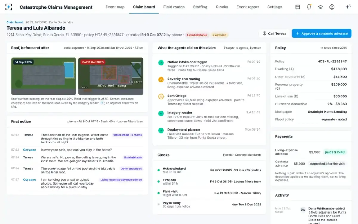
One claim, from the first call to a booked visit, with the imagery in between
Agent
Severity and routingFriday 07:20, from the first-notice call (water in three rooms, the family out of the home): uninhabitable, routed to a field visit, living-expense advance offered.
A person decides
Desk adjuster leadFriday 15:40: approves a $2,500 living-expense advance.
Agent
Imagery readerSaturday: compares the 10 October capture with the 14 September one at 7.5 cm; 38% of the roof surface missing on the rear slopes, screen enclosure down; field visit confirmed.
Never: Settling a claim from imagery.
A person decides
Catastrophe response managerAssigns the zone; only then is a visit booked.
Agent
Deployment plannerBooks Tuesday 08:30 with an adjuster 23 minutes away, uninhabitable homes first.
A person decides
Field adjusterConfirms the damage on site and writes the estimate.
The reading on the claim, with its dates and resolution
What systems does a CAT claims team use?
At least six, and most were bought separately. The claim system takes the notices. The advisories and event perimeters say where the storm went. The policy system says who is insured inside it. The imagery provider sends captures. The adjuster rosters, the carrier's and the outside firms', say who can go. In a hurricane, power outage reports by ZIP code say who cannot call. Each is a good system. None of them can answer the catastrophe manager's morning question, which is which homes need an adjuster, who can reach them, and how many more adjusters to ask for, because the answer needs all six at once.
That is the gap a catastrophe layer fills, and the reason it should read from the systems rather than replace them. The integration map at the top of this page shows the sample configuration: six inputs read, and from them the event tag and route on each claim, the dated footprint, the forecast of unreported policies, the reading per address, the zones, routes and request. The right-hand column is the part a buyer should test hardest: what happens before anything produced counts.
Does catastrophe software replace the claim system?
It should not, and in the solution it does not. The claim system remains where the claim lives, where adjusters write estimates and where payments are made. The catastrophe layer reads the notices from it, tags each to the event, adds a route with its reason and works across all of them at once, which a claim system built for one claim at a time is not designed to do. Agents never close, deny or pay a claim.
A standalone imagery tool against imagery connected to the claim
Standalone drone or aerial tool: In the vendor’s portal, one property at a time.
Connected to the claim, as in the solution: On the claim, beside the first-notice call, the clocks and the policy.
Standalone drone or aerial tool: Nothing until someone opens it and acts.
Connected to the claim, as in the solution: The claim’s route, with the reason shown, the same morning.
Standalone drone or aerial tool: In the report, if the reader looks.
Connected to the claim, as in the solution: Shown with every reading, before and after.
Standalone drone or aerial tool: Unclear: whoever opens the report.
Connected to the claim, as in the solution: Adjusters re-route and confirm on site; agents may not settle.
Standalone drone or aerial tool: A file the carrier may have to request from the vendor.
Connected to the claim, as in the solution: Each reading on the claim, with who acted on it and when.
What the claim file has to keep when imagery is used
Everything a reviewer would need to rebuild the decision. The NAIC's model claims regulation puts it plainly: "Detailed documentation shall be contained in each claim file in order to permit reconstruction of the insurer’s activities relative to each claim." For imagery that means the capture, its date and resolution, the reading, what it changed on the claim, and who acted on it. In Florida the insurer must also send the policyholder a copy of any detailed estimate its adjuster generates within seven days.
Washington's 2026 claims rule raises the bar for software of any kind. A reasonable investigation "may not rely solely on the use of a database, which includes, but is not limited to, estimating software and benchmarks gathered from one or multiple databases." Policyholders there may request any portion of the first-party claim file, photographs and video recordings included. And where a state has adopted the NAIC's model bulletin on artificial intelligence, an insurer's programme is expected to cover AI systems bought from vendors as well as those it builds (NAIC model bulletin; its requirements explained). On those terms a drone vendor's damage model is part of the insurer's programme once its readings are used on claims. The measures that show whether the reading deserves that trust are in drone inspections for insurance claims.
Buying drone roof inspection software for claims: what to check
- Is every pilot certificated, and who keeps the certificates on file?
Part 107 applies to staff, contractors and vendors alike.
- Does every reading carry the address, capture date, resolution and the pre-event comparison?
Without them a reviewer cannot judge it.
- Can it deliver thousands of readings a day in a form your systems can read?
A catastrophe is a bulk problem; a portal is a one-roof answer.
- Does it separate measurement from damage?
Measurements feed estimates; damage readings feed routing.
- What does its model decide, and what does it only suggest?
Routing, yes; payment, denial or a reduced estimate, no.
- Can the policyholder and the regulator see what you saw?
Images and readings retrievable from the claim, not only from the vendor.
- What happens in a flight restriction?
A plan for aircraft or satellite captures in the first days.
Where Catastrophe Claims Management sits beside drone software, and where it stops
The solution fits between the imagery provider and the claim system. It does not plan flights, hold pilot certificates or produce roof measurements, and it does not replace the claim system or the estimating tools adjusters use. It reads the captures a carrier already receives, compares them with the pre-event imagery, reports the date and resolution with every reading, and uses the reading as one input to route the claim. The same morning it uses the notices, the policies in force, the rosters and the outage reports to forecast tomorrow's claims and plan adjusters by drive time.
The event map: every claim, every adjuster, every unreported policy
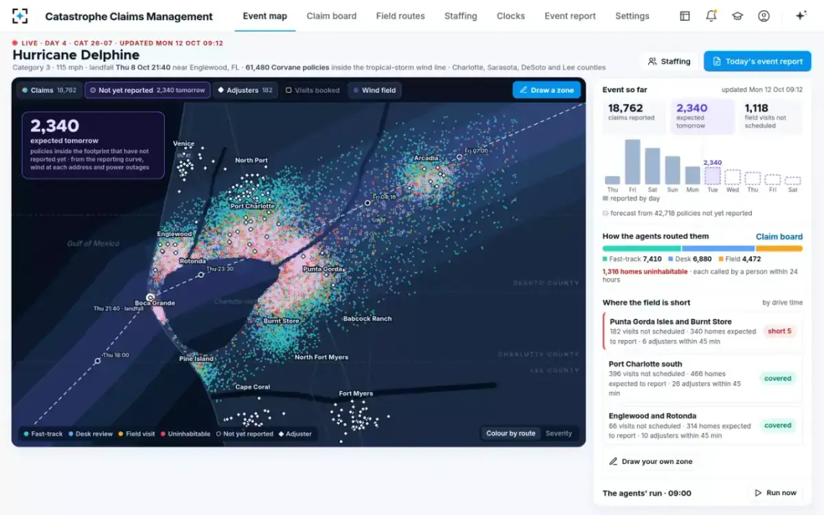
A buyer can test the fit on one past storm: the carrier's own notices, policies, rosters and the imagery it bought, run through the solution, with the routes and requests it would have drafted compared with what was done. How the forecast on the map is built, and how it differs from the catastrophe models a carrier already licenses, is covered in catastrophe modeling software vs catastrophe claims management. The whole event is on Catastrophe Claims Management.
Questions people ask
Do you need a licence to do drone roof inspections?
For commercial work in the United States, the pilot needs an FAA remote pilot certificate with a small UAS rating, or must fly under the direct supervision of someone who holds one. States may add rules for who can adjust a claim, but the drone flight itself is federally regulated.
What is in an aerial roof measurement report?
Typically the roof's areas, pitches and edge lengths, used to price a repair or replacement. It is an input to an estimate; it is not, by itself, a reading of how much storm damage the roof has.
What does drone roof inspection cost an insurer?
There is no public price list; costs depend on the provider, the number of addresses and whether the work is per flight or per capture area. The larger cost after a storm is often the claim time lost when readings do not reach the claim in a form that can route it.
Can drones fly over a hurricane zone right after landfall?
Only if the airspace is open to them. The FAA can issue temporary flight restrictions over disaster areas, and drone pilots must comply with them, so a carrier needs another source of imagery for the first days.
Does a drone inspection count as an inspection under Florida law?
Florida lets insurers investigate with electronic methods, drones included, and requires dated claim records of inspections made by electronic means as well as physical ones. It does not stop the insurer from also sending a licensed adjuster.