Drone inspections for insurance claims use photos and video taken from a drone, or from aircraft and satellites, to see a damaged property without, or before, sending an adjuster on site. After a hurricane, hail storm or wildfire they let a carrier read thousands of roofs in a day, and Florida's claim-handling law names drones among the electronic methods an insurer may use to investigate a loss. Imagery is good at what is visible from above: roof surface missing, structures down, debris, water lines. It is weak at what is not, such as interiors, water under a tarp and the difference between minor and major damage. Botminds' Catastrophe Claims Management uses imagery to route each claim to fast-track, desk review or a field visit, shows the capture date and resolution with every reading, and leaves the adjuster to confirm damage on site.
The examples come from a fictional event, Hurricane Delphine, and a fictional carrier, Corvane Mutual, as they run through the solution; their figures are sample data, not a customer result. The research and rules are linked where they appear.
Five measures for imagery that routes claims, with the formula for each
Freshness
capture date − date of loss
Imagery taken before a second storm, or weeks after a tarp went on, is reading a different roof. Report the date on every reading.
Sample claim: captured 2 days after landfall
Resolution
ground distance per pixel
The smaller the number, the finer the damage that can be seen. Report it with the reading, and compare like with like before and after.
Sample claim: 7.5 cm
Route agreement
field visits that confirm the imagery trigger ÷ field visits sent by imagery
The test that matters: when imagery sent an adjuster, did the adjuster find what the imagery said?
Measured from the field reports as visits close
Override rate
imagery-routed claims an adjuster re-routed ÷ imagery-routed claims
High means the triggers or the imagery are wrong for this event; zero means nobody is looking.
Every re-route kept with its reason and who made it
Late finds
claims kept at the desk later sent to the field ÷ claims kept at the desk
The damage imagery missed: interiors, water under a tarp, structure.
Counted from re-routes and supplements
Are drone inspections allowed for insurance claims?
Yes, and Florida says so in its claim-handling statute. An insurer investigating a residential property claim may use any method that gives it clear colour pictures or video of the loss, including "video recordings or photographs of the loss using a drone, driverless vehicle, or other machine that can move independently or through remote control." The same paragraph lets the insurer allow the policyholder to use those methods, and keeps the alternative open: "The use of electronic methods to investigate the loss does not prohibit an insurer from assigning a licensed adjuster to physically inspect the property."
Permission to use a drone is not permission to rely on it alone. The deadlines and duties of the investigation are the same whatever the camera, and the federal flood programme draws a narrower line for its own claims: FEMA allows remote adjusting only for the Dwelling Form, only where the property is accessible and does not have substantial damage, and only where the cause of loss is clearly flood. The drone pilot is regulated too; the certification and flight rules are set out in drone roof inspection software and the claim file.
What does a drone or aerial roof inspection show?
It shows the outside of the building from above, compared with what was there before. A useful reading has two images of the same roof, one before the event and one after, at a known resolution and date. From them a reader, human or software, can measure the share of roof surface missing, see a collapsed screen enclosure or a tree across the roof, find debris fields and, after a flood, water lines on walls and fences.
Take one claim in the sample event: Teresa and Luis Albarado's home in Punta Gorda, reported by phone at 07:12 the morning after landfall. The imagery reader compared a 14 September capture with Saturday 10 October's, both at 7.5 cm, and found 38% of the roof surface missing on the rear slopes, the screen enclosure collapsed and an oak limb on the lanai roof. The carrier's field-visit trigger is 25%. The call had already sent the claim to the field, because the family could not stay in the home; the reading confirmed the visit and settled nothing, and the screen says so: an adjuster confirms on site.
One roof, before and after, with the reading and its limits
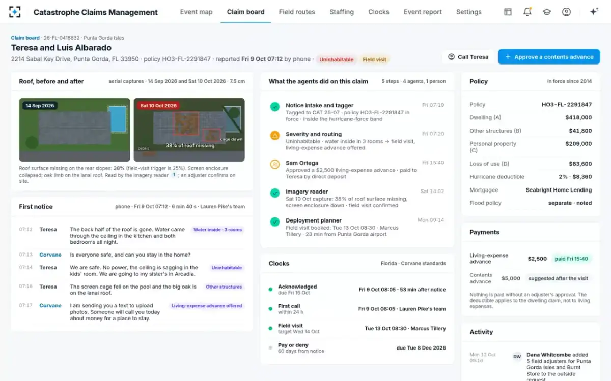
What the same images cannot show is just as specific. They do not see inside: the Albarados reported water in three rooms, which no roof photo measures. They do not see under a tarp put on after the capture. And at any resolution, the difference between a roof that leaks and one that does not can sit in a few shingles.
How accurate is aerial imagery for roof damage?
Accurate enough to find destroyed buildings and undamaged ones; much less reliable in between. The clearest public evidence is xBD, a dataset built by researchers at Carnegie Mellon University's Software Engineering Institute and the Defense Department's Defense Innovation Unit, with disaster-response agencies, which pairs pre- and post-event satellite images of 850,736 buildings with damage labels on a four-level scale. Its authors are direct about the hard part: "“minor” and “major” damage classes also have minute visual differences, and we expect most models to incur high confusion between these two classes."
How well a baseline model told damage levels apart on satellite images (F1 score)
The pattern in the bars is the useful finding. The extremes are easier than the middle, and the middle is exactly where claims money is decided: a roof with some missing shingles against one that needs replacing. The xBD authors also say their imagery scale "cannot accommodate the degree of precision that a scale meant for in-person, human assessment provides." The sample claim's aerial captures, at 7.5 cm per pixel, are about ten times finer than that satellite target, but no resolution lets a camera see under a roof deck or behind a wall.
Why accuracy alone is the wrong measure
Because most roofs after most storms are undamaged, so a reader that calls everything undamaged scores well. The xBD paper makes the point with its own data: "Accuracy by itself is a flawed metric, since a classifier that predicted “no damage” on all of the images would retain 75% accuracy." A vendor quoting a single accuracy figure for roof damage has told you mostly how many undamaged roofs were in the test.
The sample event shows the same skew. The imagery reader read 22,904 roofs over Charlotte County from Saturday's capture and found 3,861 with visible damage, about one in six. A model that missed every damaged roof would still be right about five in six. The measures that matter for a claims team are the ones in the framework above: whether the imagery is fresh and sharp enough to read, whether field visits confirm what imagery sent them to find, how often adjusters overrule it, and how much damage turns up later on claims imagery kept at the desk.
One storm’s imagery in the sample event
22,904
roofs read from one post-storm capture over one county
3,861
with visible damage, about one in six
1,840
claims sent to the field because more than 25% of the roof was missing on imagery
Four measures that matter: freshness, resolution, agreement, overrides
Freshness and resolution are properties of the image; agreement and overrides are properties of the decision. A team should report the first two on every reading and the last two on every event. Freshness matters more after a hurricane than it sounds: a capture taken before a second storm, or after a contractor has tarped the roof, is reading a different roof from the one on the claim. Resolution has to match between the before and after images, or a change in sharpness can read as damage.
Route agreement is the one that tells a carrier whether its imagery is earning its place. It is measured where the evidence is best: on the claims imagery sent to the field, by asking whether the adjuster on the roof confirmed the trigger. The override rate is its mirror. In the sample event adjusters had re-routed 214 claims by day four, and each re-route kept its reason and who made it, which is what lets a team tell an imagery problem from a trigger set too tight. Late finds, damage that surfaces on claims the imagery kept at the desk, are the slowest to measure and the most expensive to miss, because they come back as supplements and complaints.
Can an insurer settle a claim from photos only?
The rules are moving against it. Washington's claims rule, in force since 18 October 2026, says of vehicle claims that "Insurers shall not require the claimant to agree to only photo-based evaluation of damage as a condition of coverage." In explaining the rule, the commissioner pointed to reports that the industry is moving from on-site examination to artificial intelligence and photo-based adjusting. The same rule says, for every kind of claim, that a reasonable investigation may not rely solely on a database, including estimating software.
The Bureau of Labor Statistics already describes the technology as routine: "computer software can evaluate photographs of damaged property and calculate an estimated claim amount." Florida's statute permits drone photos as investigation and keeps the adjuster's visit available. None of these rules forbids a desk settlement from photos where the damage is clear and the policyholder agrees, which is how fast-track lanes work. What they point away from is photos as the only evidence when the policyholder disputes the result or the damage is not visible from above.
Can I ask for an in-person inspection?
For vehicle claims in Washington, yes: after a virtual inspection, if the claimant disagrees on the amount of loss, the insurer must accept a request for an in-person inspection and carry it out within five business days, and must tell the claimant at notification that they can ask for one. Florida's statute, which lets insurers use drones and video, does not itself set out a policyholder's right to demand a visit; it leaves the insurer free to send a licensed adjuster. For a home, the practical answer is to ask in writing and to say what the imagery cannot show, such as water inside or damage under a tarp.
Drone or aerial inspection against an adjuster on site
Drone or aerial imagery: Thousands of roofs from one capture, before roads open.
Adjuster on site: About five homes a day per field adjuster in the sample playbook.
Drone or aerial imagery: Roof surface, structures, debris, outside water lines.
Adjuster on site: Everything above plus interiors, moisture, structure and the policyholder’s account.
Drone or aerial imagery: Minor against major damage; interiors; anything under a tarp.
Adjuster on site: Scale: the visit has to be scheduled, driven to and written up.
Drone or aerial imagery: Route the claim: fast-track, desk or field, with the reason shown.
Adjuster on site: Confirm the damage and write the estimate.
Drone or aerial imagery: Capture date, resolution, before-and-after comparison.
Adjuster on site: Adjuster’s name and licence number, photos, estimate.
How Catastrophe Claims Management uses imagery: route, never settle
In the solution the imagery reader reads post-event aerial and drone captures for every reported or exposed address, and its limits are written into its role: it reports capture date and resolution compared with the pre-event capture, and imagery routes a claim but never settles one. The severity and routing agent combines the imagery with the first-notice call and the policyholder's photos to recommend a lane, and an adjuster can re-route any claim. Uninhabitable homes are never fast-tracked, whatever the imagery shows.
The overnight run in Catastrophe Claims Management: 22,904 roofs read before the manager sits down
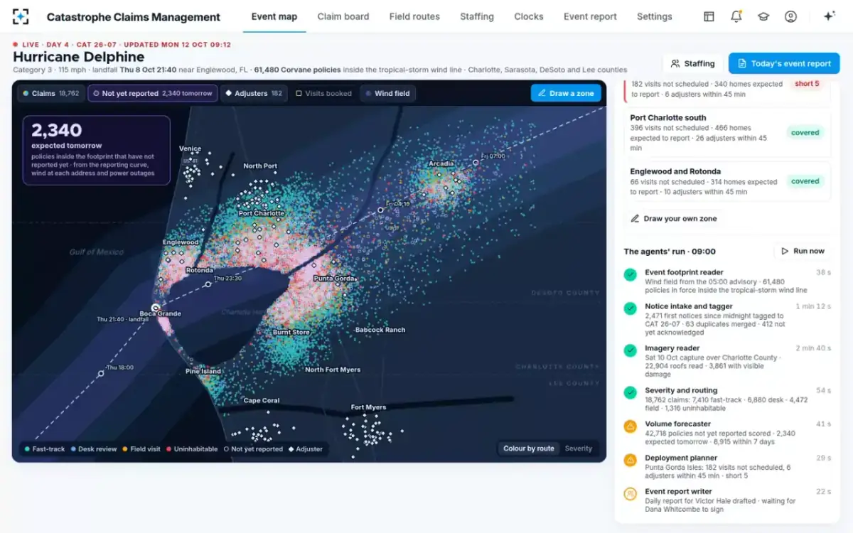
Two design choices follow from the evidence. First, imagery is a trigger for the field, not a substitute for it: the setting that sends a field adjuster when more than 25% of the roof surface is missing turns imagery's strength, spotting large visible loss, into a visit, and leaves the ambiguous middle to a person on the roof. Second, every reading carries what a reviewer needs to doubt it, the dates and the resolution, so a regulator or a policyholder can see what the carrier saw. How the visits that imagery creates are then scheduled is covered in CAT adjuster deployment.
An audit of any imagery programme in claims
- Is the capture date on every reading?
And is it after the date of loss and before any repair or tarp?
- Is the resolution stated, and the same before and after?
A sharper after-image can look like damage.
- What can imagery decide on its own?
Routing, yes. Denial, payment or a reduced estimate, no.
- How often do field visits confirm the imagery?
Measured per event from the adjusters’ reports, not from the vendor’s test set.
- How often do adjusters overrule it, and why?
Every re-route kept with its reason.
- What does it miss?
Count claims kept at the desk that later went to the field or came back as supplements.
- Can the policyholder see what the carrier saw?
Images, dates and the reading, on request.
The checklist is short because the principle is: imagery is evidence for a person's decision. The rest of the event's sorting is shown on Catastrophe Claims Management, and the morning this claim's visit was booked is followed in a catastrophe claim, hour by hour.
Questions people ask
Are drone inspections allowed for insurance claims in Florida?
Yes. Florida's claim-handling statute lets insurers investigate residential losses with electronic methods, naming photographs or video taken by drone, and lets them allow policyholders to use the same methods. Using a drone does not stop the insurer from sending a licensed adjuster to inspect in person.
Can an insurer deny a roof claim from aerial photos alone?
Rules increasingly point away from it. Washington bars insurers from requiring vehicle claimants to accept photo-only evaluation as a condition of coverage, and says no investigation may rely solely on a database or estimating software. Any denial must still rest on a reasonable investigation and explain its basis in the policy.
What resolution does aerial imagery need to show roof damage?
There is no regulatory standard. The xBD researchers targeted satellite imagery below 0.8 metres per pixel and still found minor and major damage hard to separate. The sample claim here used aerial captures at 7.5 cm, and the reading still went to an adjuster to confirm.
Is drone imagery the same as satellite imagery for claims?
No. Satellites cover whole regions quickly but at coarser resolution, and haze or cloud can obscure them; drones fly one property at a time, closer and under aviation rules. Both see only what is visible from above.
Who reviews what the imagery found?
In the solution, an adjuster. Imagery can send a claim to a field visit; the adjuster on site confirms the damage, and any adjuster can re-route a claim, with the reason kept.