A wildfire binding restrictions map shows where a carrier has stopped binding new property business because a fire is near: in effect, a line around the fire inside which agents cannot bind until it is lifted. Most of the cost of such a restriction is in where the line is drawn. Drawn by county, it stops quotes far from the fire and still misses homes in the next county that sit beside the perimeter; drawn by the perimeter and the ZIP codes around it, or by a set distance from the fire line and any evacuation order, it follows the threat. California’s moratorium law already uses the second line, Oregon’s 2026 wildfire order used evacuation ZIP codes, and neither starts from county lines. Botminds’ Binding Restriction Management draws wildfire restrictions from the fire line and evacuation orders mapped to ZIP codes, shows what the same event would stop county-wide before anyone signs, and lifts ZIP code by ZIP code.
The fire figures below are our arithmetic on the California Department of Insurance’s bulletins and the Census Bureau’s 2020 ZIP Code Tabulation Area files, both linked; the carrier, its restriction and its settings are fictional sample data in the solution.
Three ways to draw a wildfire binding line
County
The counties named in the Governor’s emergency declaration, or the county the fire is in.
Strength
Known the moment the declaration is signed; every system has a county field.
Weakness
Stops business across the whole county, far beyond the fire, and misses ZIP codes over the county line.
Perimeter and adjacent ZIP codes
The fire perimeter, and the ZIP codes within or adjacent to it: the rule California’s moratorium law uses.
Strength
Follows the fire, not the map of local government; the same ZIP codes the regulator will later freeze.
Weakness
Needs perimeter data, which changes while the fire runs, and a ZIP code table to match it.
Distance from the fire line or an evacuation order
A set distance from an active fire line, or any evacuation order nearby, mapped to ZIP codes.
Strength
Moves with the fire during the event, when binding decisions are made.
Weakness
The distance is a judgement each carrier sets and must defend, and evacuation orders have to be mapped to ZIP codes before they can be used.
What is a wildfire binding restrictions map?
It is the carrier’s answer, in ZIP codes, to the question agents ask the moment smoke is on the news: can I bind here? The restriction behind it suspends new business and coverage increases in an area near an active fire, under the carrier’s binding authority rules, and no statute we found sets where its line should fall. That freedom is the problem. Unlike a hurricane, a wildfire comes with no National Hurricane Center watch drawn between agreed coastal points; the carrier has to choose what to draw from, and the easiest thing to draw from is a county.
The map has a second use after the fire. In California every declared wildfire is followed by a one-year moratorium on cancellations and nonrenewals in ZIP codes the Commissioner lists, and a carrier that drew its binding line from the same perimeter already has most of the moratorium map before the bulletin arrives. How a moratorium ZIP code map is built and checked follows one ZIP code through that process.
The law already draws by perimeter and ZIP code
California’s moratorium statute never mentions counties. It protects property in ZIP codes inside or next to the fire perimeter, and leaves the perimeter to CAL FIRE: “the fire perimeter shall be determined by the Department of Forestry and Fire Protection in consultation with the Office of Emergency Services” (Cal. Ins. Code §675.1(b)). The Commissioner then lists the ZIP codes, fire by fire, in a bulletin. Thirteen bulletins since July 2024 have listed 366 distinct ZIP codes by our count (CDI bulletins).
The Governor’s declarations, by contrast, name counties or cities: the Franklin Fire declaration of 18 June 2025 covered the City of Malibu, the Gann Fire declaration of 6 August 2026 covered Calaveras County (CDI Bulletin 2025-12; CDI Bulletin 2026-6). Comparing the two shows how far a county line sits from the fire.
How much of a county a fire’s ZIP codes really cover
Less than a county rule assumes, often much less. For seven fires since 2024 we measured how much of the land of the counties named in each declaration lies inside the ZIP codes the Commissioner listed. For the Franklin Fire it was 5%; for the Los Angeles fires of January 2025, the longest list since 2024 with 96 ZIP codes, about a third; only for the Gann and Mountain fires did the listed ZIP codes cover more than half.
Share of the declared counties’ land inside the moratorium ZIP codes, seven California fires
Franklin · Los Angeles County
- Inside the listed ZIP codes · 5%
- Rest of the declared counties · 95%
Hughes · Los Angeles and Ventura
- Inside the listed ZIP codes · 16%
- Rest of the declared counties · 84%
Palisades, Eaton and five more · Los Angeles and Ventura
- Inside the listed ZIP codes · 34%
- Rest of the declared counties · 66%
Gifford · San Luis Obispo and Santa Barbara
- Inside the listed ZIP codes · 47%
- Rest of the declared counties · 53%
TCU Lightning Complex · Calaveras and Tuolumne
- Inside the listed ZIP codes · 49%
- Rest of the declared counties · 51%
Gann · Calaveras
- Inside the listed ZIP codes · 62%
- Rest of the declared counties · 38%
Mountain · Ventura
- Inside the listed ZIP codes · 68%
- Rest of the declared counties · 32%
Land is not the same as policies, and a carrier should run the same comparison on its own book; the direction is the point. A county-wide binding stop for the Franklin Fire would have closed binding across all of Los Angeles County to protect an area whose listed ZIP codes cover a twentieth of its land.
ZIP codes outside the declared county
The county rule fails the other way too. Because the law takes ZIP codes adjacent to the perimeter, the lists regularly include ZIP codes that lie wholly outside the counties the Governor named. Of the 22 Gann Fire ZIP codes, 9 have no land in Calaveras County; they sit in Amador, Sacramento, San Joaquin, Stanislaus and Tuolumne. A carrier that stopped binding by county would have kept writing in all nine.
Listed ZIP codes lying wholly outside the counties named in the declaration
One of the Gifford Fire ZIP codes, 93023, lies wholly in Ventura County, although the declaration named San Luis Obispo and Santa Barbara. A guard keyed to the declared counties would have released nonrenewals there, and a binding map keyed to them would never have stopped binding there.
Wildfire binding restrictions in Oregon: the evacuation notice as the line
Oregon’s regulator drew its 2026 wildfire order by ZIP code and evacuation, not by county. The Governor declared a statewide emergency on 16 June 2026; the Department of Consumer and Business Services’ order of 31 July applied to areas “specified by ZIP code or other appropriate means of delineation” in bulletins (Oregon Wildfire Emergency Order), and the Governor’s office described the protections as covering “ZIP codes subject to wildfire evacuation notices” (Oregon Governor’s office). The order suspended cancellations and nonrenewals and extended grace periods; it lasts 30 days at a time, and on 28 August it was extended to 29 September (Oregon DFR).
Like Florida’s and California’s, Oregon’s order is about existing policies; it does not tell a carrier where to stop binding. But it shows the line a regulator found workable during a fire season, evacuation notices mapped to ZIP codes, and that line is available to a carrier’s binding rules on the same day.
Setting the distance: a fire line, an evacuation order, a mileage
A binding line during a fire has to be drawn before any perimeter is final, so it is usually a distance. The sample carrier’s setting suspends binding within 10 miles of an active fire line or any evacuation order; the solution maps that buffer to ZIP codes, snaps to whole ZIP codes and shows the county-wide count beside it. The number is a judgement each carrier sets and versions, not a standard, and it is the first thing a regulator or a reinsurer will ask to see justified.
Wildfire as one trigger among several in Binding Restriction Management, set in miles
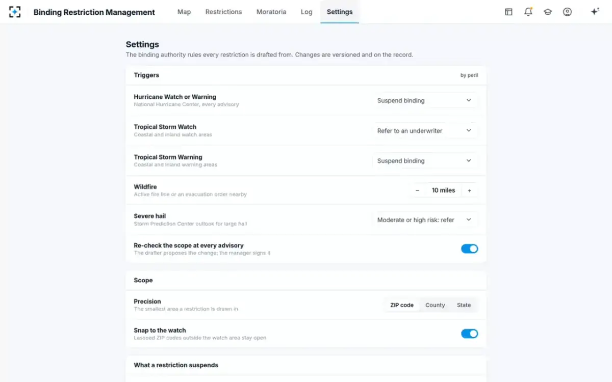
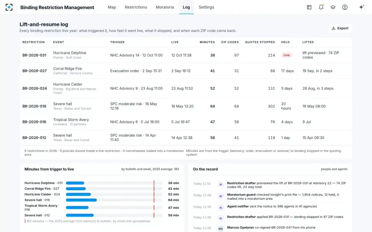
The sample log shows the result on one fire. An evacuation order near the Corral Ridge Fire in Ventura County came at 15:31 on 2 September; the restriction went live at 16:12, 41 minutes later, across 31 ZIP codes, and stopped 88 quotes. It stayed on for 17 days and lifted in two steps on 19 September.
Binding Restriction Management: a wildfire restriction beside hurricanes and hail on one log
When does a wildfire binding restriction lift?
When the carrier’s written conditions are met, ZIP code by ZIP code. For hurricanes the sample carrier lifts when the watch is discontinued, no warning or evacuation order remains and damage reports are below its threshold; for fire the equivalent conditions are the carrier’s to write, and the fire line moving away and evacuation orders lifted are the obvious ones. A lift should not wait for the whole fire to be declared out if most of the ZIP codes are clear, and it should not reopen a ZIP code that is still under an evacuation order because the county next door has reopened.
In California, the lift of a binding restriction and the start of a moratorium often meet. A ZIP code reopening for new business may at the same time be frozen against wildfire-risk nonrenewals for a year from the declaration. What happens to notices sent before the bulletin is covered separately.
Wildfire binding restrictions in California, and the 2025 coverage commitments
California adds a reason to keep the line tight. Under the Department of Insurance’s Sustainable Insurance Strategy, “insurers utilizing Department-reviewed wildfire catastrophe models will be mandated to provide and maintain coverage in wildfire-prone areas” (CDI, 1 August 2025). A carrier that has committed to write in wildfire-prone areas, and then closes whole counties every time a fire starts, will find its binding log and its commitment hard to read together. A restriction drawn to the perimeter and lifted ZIP by ZIP keeps both.
Carriers also have public risk maps to draw on before any fire starts, such as the USDA Forest Service’s Wildfire Risk to Communities, built at the direction of Congress (USDA Forest Service). Those maps describe standing risk, which is an underwriting question; a binding restriction answers a different one, where a fire is burning today.
County rule vs perimeter rule for a wildfire binding restriction
Drawn by county: Immediate: the declaration names the counties.
Drawn by perimeter, distance and ZIP code: Minutes, if fire line and evacuation feeds are mapped to ZIP codes in advance.
Drawn by county: The whole county: for the Franklin Fire, 95% of Los Angeles County’s land lay outside the listed ZIP codes.
Drawn by perimeter, distance and ZIP code: Only the buffer around the fire, set by the carrier and kept with the restriction.
Drawn by county: Adjacent ZIP codes over the county line: 9 of 22 for the Gann Fire.
Drawn by perimeter, distance and ZIP code: Follows the fire across county lines, as the moratorium law does.
Drawn by county: A different set of areas from the bulletin that follows.
Drawn by perimeter, distance and ZIP code: Close to the bulletin’s ZIP codes, which come from the same perimeter.
Drawn by county: Nothing new.
Drawn by perimeter, distance and ZIP code: Fire line and evacuation feeds, a ZIP code table, and a distance the carrier can defend.
What to look for in a wildfire binding map
The test of a wildfire map is not how it looks on the day of a demonstration; it is whether the line it draws on a real afternoon would stand up to the agents who lose business inside it and the examiner who reads the log afterwards.
Questions for any wildfire binding restrictions map, vendor or in-house
- What does it draw from: county, perimeter, fire line, evacuation orders?
And can the carrier choose per peril and per state, with the choice versioned?
- Does it map to whole ZIP codes across county lines?
Nine of the Gann Fire’s 22 moratorium ZIP codes lie outside the declared county.
- Does it show what the same fire would stop county-wide, before anyone signs?
The comparison is what justifies the scope later.
- How often does it refresh the fire line and evacuation orders, and who signs a change?
A fire moves faster than an advisory cycle; each change should be proposed and signed, not applied silently.
- How does it lift?
ZIP code by ZIP code, on written conditions, with the same two signatures as the stop.
- Does the same map feed the moratorium check after the fire?
In California the bulletin’s ZIP codes come from the same perimeter; matching them should not start from scratch.
Binding Restriction Management fits the middle of that list: it maps fire lines and evacuation orders to ZIP codes with the carrier’s distance, runs the dry run, needs two signatures to apply and lift, and carries the ZIP codes into the moratorium guard. It does not forecast where a fire will spread, and it depends on the fire and evacuation feeds a carrier connects; where an evacuation zone cannot be mapped to ZIP codes with confidence, the drafter asks a person rather than guessing.
Questions people ask
Are there wildfire binding restrictions in California?
Carriers set them, under their own binding rules; California law does not require or define them. What the law does set is the moratorium that follows a declared fire: no cancellation or nonrenewal due to wildfire risk, for one year, in ZIP codes within or adjacent to the perimeter, which since 2026 reaches commercial property too.
Do insurers stop binding for a brush fire in California?
A carrier’s rule usually turns on distance and evacuation, not on what the fire is called. The sample carrier suspends binding within 10 miles of any active fire line or evacuation order, so a small brush fire near homes triggers it and a large fire in empty country may not.
Are there wildfire binding restrictions in Oregon?
Carriers writing in Oregon set their own; the state’s 2026 wildfire emergency order addressed cancellations, nonrenewals, grace periods and claims for policies in ZIP codes subject to evacuation notices, not new business. The order ran from 31 July 2026 and was extended to 29 September.
What is an Oregon insurance emergency order?
An order the director of the Department of Consumer and Business Services can issue under ORS 731.870 when the Governor declares an emergency, covering claim reporting, grace periods for premium and temporary postponement of cancellations and nonrenewals. Each order lasts at most 30 days and can be extended for further 30-day periods.
Where can I find California fire zones by ZIP code for insurance?
For the moratorium, in the Department of Insurance’s bulletins, which list ZIP codes fire by fire from the declaration date; 366 distinct ZIP codes since July 2024 by our count. Standing wildfire risk is a separate question, which public tools such as the Forest Service’s Wildfire Risk to Communities describe by community.