Insurance aerial imagery software comes in two kinds. The first captures images from aircraft, drones or satellites and sells them, often with attributes derived from them: roof shape and tones, pools, trees, solar panels. The second puts those images to work in an underwriting decision. Most homeowners insurers already license the first kind, already order exterior inspections and can already pull county permits. What is usually missing is the work between those sources: for one parcel, every capture with its date and resolution, the inspection and the permits, lined up against what the application said, and one decision written back with its evidence. Botminds' Aerial Imagery Verification is that layer. It does not capture or sell imagery; its seven agents read the captures and inspections a carrier already buys, and write back a cited finding that a homeowners underwriter decides on and signs.
Examples come from a fictional sample carrier, Norland Mutual, and its sample referral for 1127 Wrenfield Court in Ellicott City, Maryland. The carrier, people, inspection firm and figures are invented sample data.
What a homeowners carrier already has, and what is missing between the pieces
Already licensed or ordered
- Aerial and satellite captures, licensed over whole areas
- Attributes a vendor derives from them: roof shape, tones, pools, trees
- Exterior inspection reports and photos from inspection firms
- County permits, assessor and homestead data
- Roof and wind mitigation certificates sent by policyholders
- The filed rating manual and underwriting guidelines
Missing between them
- Each capture placed on the insured parcel, with its offset measured
- Each capture’s fitness judged for the use: feature, roof age or condition
- One line per attribute with every source beside the application
- Each line priced from the manual, with the rule cited
- A rule that nothing adverse rests on one source
- One message to the agency and an evidence pack for the homeowner
What does insurance aerial imagery software do, and what does it leave undone?
Imagery software shows a property from above, measures what it can see and, increasingly, scores it. What it leaves undone is the comparison: whether this capture is of this house, whether it is recent and sharp enough for the decision at hand, and whether the application, the inspection and the permits agree with it. Those are the questions regulators now ask.
Colorado's 2026 bulletin states the limit plainly: "aerial imagery has limitations and should not be treated as definitive or determinative on its own" (Colorado Bulletin B-5.57). It also states the scope: the bulletin "applies equally to tools and data developed and used internally by insurers as well as tools and data provided by third-party vendors". Buying a tool does not move the responsibility for what it concludes.
What a homeowners carrier already buys: captures, attributes, inspections, permits
A carrier buying imagery software is rarely starting from nothing. Connecticut's insurance department tells homeowners that insurers inspect in person and by "Aerial imagery, such as satellite images or drone photography", and that "Insurers often use a combination of these tools" (Connecticut advisory). In practice that means at least three paid sources per referral: one or more licensed captures, an inspection firm's report, and property data.
The sample referral is typical. It carries the application signed on 6 October with 41 answers, three captures (14 August 2026, 3 April 2025 and 21 June 2023), an exterior inspection by an invented firm with 31 photos, and county permits for a pool, a solar array and two roof jobs. Each source was bought or collected for a reason. None of them, on its own, says what the premium should be.
Aerial imagery for insurance is a dated, parcel-level source, not a verdict
An aerial capture is evidence of what a parcel looked like on one day, at one resolution. Used that way it is very good: it finds pools, outbuildings and solar arrays the application left out, and it dates changes between captures. Used as a verdict on condition, it fails in the ways regulators have catalogued.
The law already draws this distinction. Louisiana's statute limits how old an image may be when it is relied on alone to identify the condition behind a cancellation or nonrenewal, but an image used only to find and locate the property may be of any age (La. R.S. 22:1339). Colorado makes the same cut by use: imagery good enough to identify a parcel or assess a community's risk may not be good enough to decide a property's condition or a claim (Colorado Bulletin B-5.57; how to test a tool against that cut is in the aerial imagery underwriting tool test). Software that treats every capture as equally good for every purpose is out of step with both.
The integration map: what is read, and what is written back
Aerial Imagery Verification reads six kinds of source and writes back five things, all to people. Nothing it writes goes to an agency or a homeowner until the underwriter sends it, and nothing adverse goes without a second signature.
Aerial Imagery Verification: sources read, decision written back
Read
Seven agents
- Application reader
- Parcel matcher
- Imagery analyst
- Inspection reader
- Property data checker
- Reconciler
- Question and notice drafter
Then a homeowners underwriter decides; a manager co-signs anything adverse.
Written back
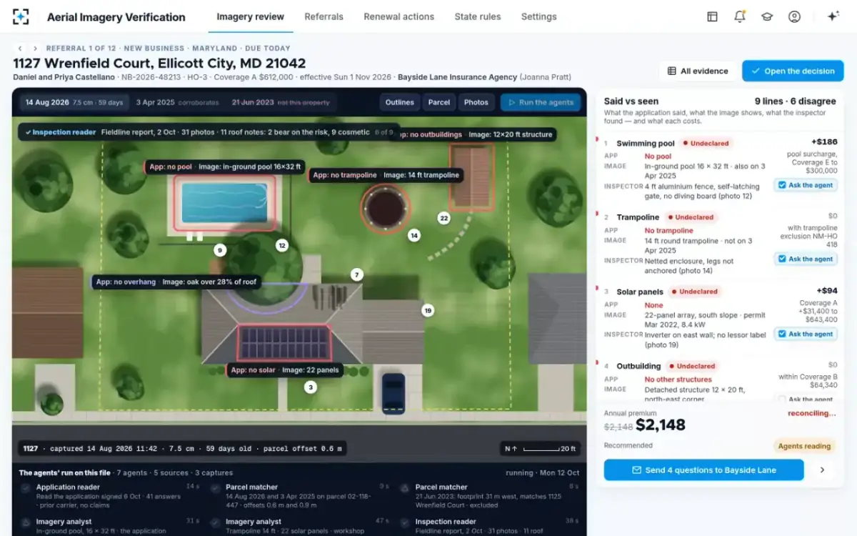
On the sample referral the agents read five sources and three captures in 3 minutes 40 seconds. The premium on screen reads "reconciling" until the last line is priced, so nobody acts on a half-finished picture.
The agents at work on the captures the carrier already licenses
Insurance aerial imagery data: the fields every capture must carry
Imagery is only as usable as the facts that come with it. A capture without a date cannot be checked against a state's age rule; without a resolution it cannot be judged fit or unfit for a condition finding; without a footprint it cannot be matched to a parcel. Before integrating any feed, check that each of these fields arrives with every capture, not on request.
The data each source must carry for an imagery referral
| Source | Fields needed | What breaks without them |
|---|---|---|
| Aerial or satellite capture | Capture date and time; ground resolution; cloud and shadow cover; building footprint; orthorectification method | The state’s age rule, the resolution floor for condition, and the parcel match cannot be applied |
| Derived attributes | The capture each attribute came from; the measurement; the vendor’s model version | An attribute cannot be traced to a picture a homeowner can be shown |
| Inspection report | Visit date; inspector; numbered photos; each observation tied to a photo | A finding cannot cite its photo, so it cannot be checked or disputed |
| Permits and assessor data | Permit number, date and scope; assessor area and year built; homestead status | Roof age and occupancy have no second source |
| Application | Each answer as given; date signed; producer | There is nothing to reconcile against |
Colorado's list is the useful checklist here: the ground resolution, how well the image was corrected for terrain and camera angle, the elevation model behind it, how the capture date sits against the event in question, and the fact that a camera above sees only surfaces (Colorado Bulletin B-5.57). A feed that cannot tell the software at least the date, the resolution and the footprint is a picture, not data.
Insurance satellite imagery or aerial imagery: what decides what a capture can judge
For an underwriting decision the platform matters less than the capture's date and resolution. Maryland's bulletin covers both, satellite images "captured from a satellite orbiting the Earth" and aerial images taken from planes or drones, and applies the same test to each: the image must give a clear, accurate and current view of the property before it can support a cancellation, nonrenewal or claim denial (Maryland Bulletin 25-10).
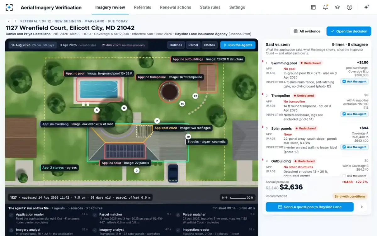
The sample file shows why resolution is the fact to check. The August 2026 capture is 7.5 centimetres a pixel, sharp enough to see two shingle tones. The June 2023 capture is 15 centimetres and 40 months old, and it turned out to show the neighbour's house in any case. The sample carrier reads roof condition only from captures at the resolution it sets, 7.5 centimetres by default, and only where cloud, shadow and trees cover less than 30% of the roof. A coarser capture can still count a pool.
One capture, every feature outlined, each against the application
What the rules ask of software bought from a vendor
Responsibility stays with the insurer, whoever built the tool. The NAIC's model bulletin on insurers' use of AI, which 29 jurisdictions had adopted by 8 October 2026 (NAIC adoption map), expects an insurer's AI programme to cover how it vets a third party and the data or AI systems it buys from it, so that any decision those systems make or support that could harm a consumer still meets the standards the law sets for the insurer (NAIC Model Bulletin). It also suggests contract terms giving audit rights and requiring the vendor to cooperate with regulators.
The imagery bulletins make the same point in their own words. Tennessee's covers imagery an insurer buys as well as imagery it collects (Tennessee Bulletin 25-03), Colorado's covers vendor tools equally, and Maryland sends insurers whose AI reads or enhances aerial images to its AI bulletin, 24-11 (Maryland Bulletin 25-10). For a buyer, that turns the vendor questions below from nice-to-have into the evidence an examiner will ask for.
Questions to ask before you buy insurance aerial imagery software
Ask for what you will need to show a homeowner, an examiner or a hearing officer, because that is where the tool's output ends up. A score with no picture behind it, no date and no parcel check is the evidence the state bulletins say is not enough.
Questions for any insurance aerial imagery software vendor
- Does every finding cite the capture it came from, with date and resolution?
An attribute you cannot trace to a picture you can show is not evidence.
- Does it check each capture is of the insured parcel before reading it?
Ask how the offset is measured and what happens past the tolerance.
- Does it refuse to judge condition from a capture too old, too coarse or too cloudy?
And does it apply each state’s age rule, not one national default?
- Does it separate cosmetic wear from conditions that bear on the risk?
Several states say streaking and discoloration alone do not support action.
- Does it read your inspection reports, or only its own imagery?
The inspection is the second source most adverse actions need.
- Can it price each mismatch from your filed manual?
A finding without a premium effect leaves the underwriter to do the arithmetic.
- Who decides, and who signs?
Recommendations only, with named people on every decision and two on anything adverse.
- Can you audit it and test it on your closed referrals?
Audit rights and regulator cooperation are in the NAIC model bulletin’s list.
The last question is the one to insist on. How to run that test, on referrals your inspectors have already settled, is set out in testing an aerial imagery underwriting tool on referrals you closed.
Where Aerial Imagery Verification fits, and where it does not
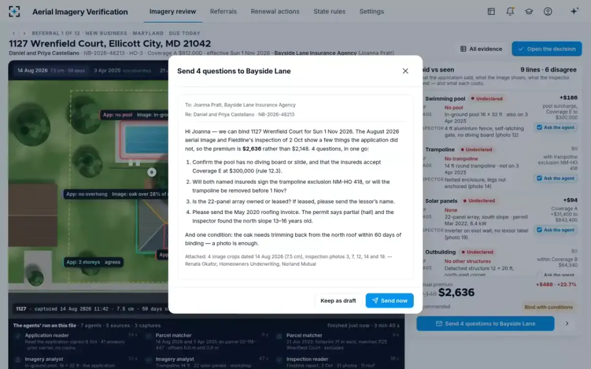
Aerial Imagery Verification sits between the imagery a carrier licenses and the decision a carrier signs. It does not fly, capture or sell imagery, replace the inspection firm, or replace the policy administration system. It reads what those produce, matches each capture to the parcel, outlines and measures each feature, classes each roof observation, prices each mismatch from the carrier's manual, and drafts one message to the agency and, where an action is adverse, the homeowner's evidence pack. A homeowners underwriter decides and signs; the underwriting manager co-signs every decline, cancellation and nonrenewal.
It also does not make an imagery programme right by itself. A carrier whose captures arrive without dates, whose inspection reports do not number their photos, or whose guidelines let one image carry a nonrenewal will find those gaps on the first day, because the solution shows each line's source. That is the point of it, and also the work of going live.
What goes back out: one message, with the evidence attached
Going live on the captures you already license
Going live starts with what the carrier already has. The inputs are its underwriting guidelines, its rating manual, its imagery and inspection sources, and a sample of past referrals; the solution is configured from those, and its settings (image age, resolution for condition, parcel tolerance, cloud cover, roof-age rule, second-source rule, inspection on dispute) are set to the carrier's policy with each state's rule applying where it is stricter.
Then the solution is run on that sample of past referrals, so the carrier can compare its findings with the decisions its own underwriters made, before a live referral is touched. Botminds estimates that an imagery referral that takes about 70 minutes by hand takes about 11 with the agents doing the reading; that is a design estimate, and the replay is where a carrier checks it on its own files. The full referral, screen by screen, is on the Aerial Imagery Verification page.
Questions people ask
Which insurance companies use aerial imagery?
Homeowners insurers use it alongside in-person inspections; Connecticut's insurance department says insurers often use a combination of the two. In an NAIC survey of 194 homeowners insurers on 2022 data, underwriting was reported at 47% among the uses of advanced AI or machine learning. We do not name vendors or carriers.
What are property data underwriting services?
Services that supply facts about a property for underwriting: aerial captures and attributes derived from them, building characteristics, permits, assessor data and inspection reports. Each is a source, not a decision, and the state imagery bulletins expect an adverse decision to rest on more than one.
How current is the aerial imagery insurers use?
It varies by capture, which is why the date has to travel with each image. Colorado's bulletin expects imagery used for general underwriting and rating to be no more than 12 months old, and Louisiana's statute bars relying solely on images more than 24 months old for a condition-based cancellation or nonrenewal. The sample file's main capture was 59 days old.
Can aerial imagery software decide a nonrenewal on its own?
It should not, under the state rules we read: Maine, Tennessee and West Virginia describe imagery as one tool among others, and Colorado says visible conditions in imagery should not be the sole basis for an adverse action. In Aerial Imagery Verification the agents recommend, the underwriter decides and a manager co-signs anything adverse.
Do we need new imagery to use Aerial Imagery Verification?
No. It reads the captures, inspection reports, permits and certificates a carrier already licenses or receives. What it does need is the metadata that comes with them, above all each capture's date, resolution and footprint, so that each finding can be dated, judged fit for its use and placed on the right parcel.